Cameron Poolecpoole.dev
/career-history

Experience & Track Record

A hybrid systems engineer and geospatial data architect with formal engineering training and over a decade of production data infrastructure experience across Australia and the UK. Proven delivery across municipal data infrastructure (Greater London Authority), climate hazard modelling (Geoneon), and automation software.

Current availability

Available for focused, short-term contract work and open to senior data, software, or geospatial engineering positions.

Global Spatial Deployments

Interactive MapLibre Island

Selected project locations

11 project locations

Loading the interactive map. Project summaries are available below.

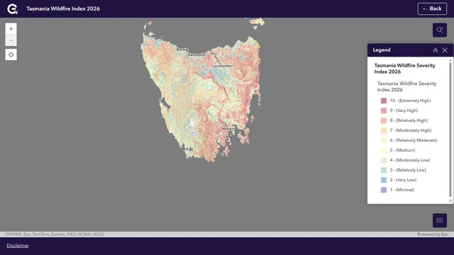
Geoneon Tasmania Wildfire Index 2026 statewide WSI map with severity legend and source credits
Geoneon Tasmania Wildfire Index 2026: statewide WSI layer. Captured 2 October 2026; map and basemap credits shown in the image.

Tasmania Wildfire Index — Statewide Data Engineering

Geoneon

Tasmania (statewide; Hobart delivery base) / Dec 2025 — Jul 2026 (statewide production)

Led input preparation, large-scale analysis and delivery QA for the published 2026 Index, assessing 450,356 building footprints across 29 LGAs. Separate evacuation exposure analysis delivered for Hobart and Kingborough.

Read case study

Basemap: MapTiler. Data: OpenStreetMap contributors. See the map for additional source attribution.

Read all project summaries (11)
  • Tasmania Wildfire Index — Statewide Data Engineering

    Tasmania (statewide; Hobart delivery base)

    Geoneon / Dec 2025 — Jul 2026 (statewide production)

    Led input preparation, large-scale analysis and delivery QA for the published 2026 Index, assessing 450,356 building footprints across 29 LGAs. Separate evacuation exposure analysis delivered for Hobart and Kingborough.

    Read case study
  • DFES Bushfire-Prone Area Mapping

    Albany, Western Australia

    Geoneon / DFES WA / 2024 – 2025

    Automated satellite imagery pipelines and AI vegetation classification assessing bushfire hazard compliance.

  • Native Title Land Rights Cartography

    Geraldton & Pilbara, WA

    Yamatji Marlpa Aboriginal Corporation (YMAC) / 2014 — 2018

    Cadastral spatial infrastructure, legal boundary management, and heritage cartography across Western Australia.

  • London Datastore & Cool Spaces Infrastructure

    London, United Kingdom

    Mayor of London — Greater London Authority (GLA) / Jan 2021 — Nov 2021

    City-scale public spatial pipelines, ArcGIS Enterprise administration, and climate-resilience platforms mapping civic cooling infrastructure.

  • National Wildfire Severity & Climate App

    Thimphu, Bhutan

    Geoneon / Climate Partners / 2024

    National-scale satellite workflows delivering wildfire severity layers and building exposure models for web decision tools.

  • Building-Level Dasymetric Population Mapping

    Vientiane, Laos

    Geoneon / 2025

    Mass-preserving population disaggregation down to structures for flood screening and local data capacity training.

  • UNDP Conservation & Climate Platform

    Port Moresby, Papua New Guinea

    Mammoth Geospatial / UNDP / Prior Delivery

    Interactive web mapping platform visualising environmental risk, protected reserves, and conservation indices.

  • YMCA Facility Catchment Analytics

    Attleboro, Massachusetts, United States

    Mammoth Geospatial / Seer Analytics / 2016 — 2020 (public project period)

    PMA market analytics for the YMCA of Attleboro, showing drive-time catchments, member locations, and demographic block groups.

    Read case study
  • Satellite Vegetation Height vs NASA GEDI LiDAR

    Pacific Islands Basin

    Digital Earth Pacific / Geoneon / 2023 — 2026 (Geoneon engagement)

    Validation of satellite-derived vegetation-height products against NASA GEDI reference observations, accounting for differing spatial support.

  • BNPB AI Social Vulnerability & Spatial Training

    Padang Panjang, Indonesia

    BNPB / Geoneon / 2025

    Delivering technical workshops on dasymetric redistribution algorithms and AI disaster exposure workflows.

  • Pan-African Student Systems & Serverless Integration

    Kigali, Rwanda

    ALX / African Leadership University / 2020 — 2022

    Serverless AWS integration pipeline synchronising high-volume admissions, assessment scores, and CRM automations across Pan-African student cohorts.

    Read case study

Production Roles (Chronological)

2010 — Present

Independent Geospatial Software & Data Consultant

Current Practice
cpoole.dev • Hobart, TAS
2019 — Present

Independent software development and data consulting practice delivering spatial ETL pipelines, workflow automation, and fast web platforms.

Key Systems & Deliverables:
  • →Built fast static web platforms with Astro and TypeScript, adding MapLibre GL and Cloud-Optimised PMTiles where interactive mapping was required.
  • →Engineered Peritas Portal Frame Builder, an automated structural engineering add-in for Autodesk Revit (.NET 8 / C#), modelling industrial portal frames, canopies, crane runways, and cold-formed framing with decoupled geometry validation.
  • →Governed agentic coding workflows using repository-level specification constraints (AGENTS.md), deterministic test suites, and strict human review across spatial and web deliverables.
  • →Engineered an event-driven AWS serverless integration engine (AWS Chalice, SQS, DynamoDB, Lambda) for ALX / African Leadership University, synchronising student admissions, Holberton testing metrics, and CRM automations across Pan-African cohorts.
  • →Built automated packaging pipelines producing signed, deterministic Windows installers (.msi) using WiX Toolset v5 and PyInstaller for enterprise workstation deployment.
C# / .NET 8AWS (Lambda, SQS, DynamoDB)PythonAWS ChaliceRevit API SDKGDAL/OGRPostGISWiX Toolset v5AstroMapLibre GL

Lead Data Engineer

Completed Senior Role
Geoneon • Hobart, TAS
2023 — 2026

Led geospatial data engineering, remote-sensing pipelines, and climate risk modelling workflows across Australia and international programs, delivering reproducible analytics for state government and council stakeholders.

Tasmania Wildfire Index 2026: statewide data-engineering case study

Key Systems & Deliverables:
  • →Led statewide input preparation, analysis and delivery QA for the published Tasmania Wildfire Index 2026, assessing 450,356 building footprints across 29 LGAs; delivered separate evacuation exposure analysis for Hobart and Kingborough and wildfire pipelines for Bhutan.
  • →Integrated bounded agentic coding workflows for geospatial algorithm refactoring and test generation, backed by deterministic GIS unit test validation.
  • →Developed tree-canopy extent, temporal change, canopy-height and greening-prioritisation workflows for Brighton, Clarence, Devonport, Hobart and Kingborough councils, with methods varying by project.
  • →Engineered satellite imagery and automated vegetation classification pipelines for Western Australia (DFES) and NSW bushfire-prone area mapping pilots.
  • →Engineered open building footprint validation and conflation pipelines across Overture Maps, OSM, and cadastral datasets, filtering ML false positives and publishing audited exposure inventories.
  • →Constructed mass-preserving dasymetric population allocation pipelines down to building structures in Laos and validated satellite vegetation height models against NASA GEDI spaceborne LiDAR in the Pacific.
  • →Automated batch raster processing with GDAL, Rasterio, and xarray, outputting Cloud-Optimised GeoTIFFs (COGs) and STAC-compliant metadata for client web applications.
PythonGDALRasterioxarrayPostGISSentinel-1/2NASA GEDIOverture MapsOpenStreetMapShapelyQGISArcGIS Pro

Geospatial Developer & Consultant

Mammoth Geospatial • Hobart, TAS
2016 — 2023

Systems architecture, software maintenance, and spatial data engineering with an emphasis on open data and open source mapping solutions for clients including UNDP, Seer Analytics, Agronomeye, and Kaleka.

Key Systems & Deliverables:
  • →Designed and implemented RESTful APIs, ORM data modelling, and backend services to power web applications and interactive web mapping solutions, collaborating with frontend developers and project managers.
  • →Engineered and deployed cloud system infrastructure on AWS, building and administering containerised applications with Docker and CI/CD pipelines for international organisations including the UNDP.
  • →Designed relational database schemas and administered PostgreSQL/PostGIS with GiST indexing, streaming replication, and performance tuning, executing automated testing, QA, and debugging routines.
  • →Performed statistical and geospatial analysis of complex client datasets and built custom internal and external QGIS plugins to automate analytical workflows.
PythonGDAL/OGRPostgreSQL / PostGISAWSDockerREST APIsQGIS

Data Engineer & Analyst

Mayor of London — Greater London Authority (GLA) • London, UK
Jan 2021 — Nov 2021

Provided high-quality spatial data engineering and advice supporting policy development and municipal services. Automated data processing and open data enrichment for the London Datastore and supported the Cool Spaces initiative.

Key Systems & Deliverables:
  • →Developed automated ETL pipelines ingesting high-volume municipal and demographic datasets published directly to the London Datastore.
  • →Administered cloud-hosted ArcGIS Enterprise software powering interactive web maps, spatial REST APIs, and data visualisations for the London Datastore.
  • →Engineered spatial data infrastructure and analytics for the Cool Spaces application, identifying and cataloguing public refuge locations during heatwaves.
  • →Maintained PostgreSQL/PostGIS databases and deployed AWS infrastructure, maintaining API documentation and automated testing routines.
PythonPostgreSQL / PostGISArcGIS EnterpriseAWSREST APIsJSON SchemaDocker

Geospatial Specialist & Spatial Lead

Yamatji Marlpa Aboriginal Corporation (YMAC) • Perth & Hobart, Australia
2014 — 2018

Tailored solutions for spatial operations, data management, automation, training, and production of legal cartographic evidence for Native Title claims across Western Australia.

Key Systems & Deliverables:
  • →Built and maintained a Django-based spatial portal streamlining data requests, downloads, and document management across 12+ years of historical data.
  • →Installed and managed spatial data infrastructure using PostgreSQL, Geoserver, and FME Server, automating external downloads from over 20 disparate sources.
  • →Authored authoritative court and tribunal cartographic exhibits reconciling complex tenure, pastoral leases, mining tenements, and heritage survey data.
  • →Trained technical and non-technical staff across the organisation in geospatial tools and solutions.
PostgreSQL / PostGISGeoserverFME ServerDjangoPythonQGIS

Senior Linkage Officer

Department of Health WA | Data Linkage Branch • Perth, WA
2010 — 2014

Worked within a specialist team responsible for linking core population datasets for over 2 million citizens and extracting data cohorts for researchers.

Key Systems & Deliverables:
  • →Executed deterministic and probabilistic record linkage algorithms joining multi-million record longitudinal registries while enforcing privacy protocols and cryptographic hashing.
  • →Served as a senior team member training incoming staff in branch practices and linkage strategies.
  • →Assisted with the development and testing of linkage tools to increase match efficiency and audit dataset completeness.
  • →Collaborated with epidemiological researchers on complex case-control cohort extracts.
SQLRelational DatabasesData Linkage AlgorithmsCohort AnalysisCryptographic Matching
/academic-foundation

Academic Qualifications & Systems Rigour

Formal training in software engineering principles, memory models, algorithms, and data integrity combines with scientific research methodology to inform production software architecture.

Graduate Studies
Graduate Studies in Software Engineering
The University of Western Australia (Perth, WA)

Postgraduate coursework covering software architecture, systems programming, data structures, algorithm efficiency, and relational database systems.

Undergraduate Degree
Bachelor of Science (B.Sc.), Health Science
The University of Western Australia (Perth, WA)

Focus on biostatistics, research methodologies, epidemiology, and data collection standards, providing the foundation for population-level linkage algorithms.