
QGIS Plugins, Web Applications & Open-Source GIS Systems
Building geospatial software, automation and spatial data infrastructure with QGIS, Python, PostGIS and open-source web technologies.
- Client Projects
- UNDP, Agronomeye & Kaleka
- GIS Engineering
- QGIS Plugins & Automation
- Spatial Systems
- PostGIS, GeoNode & Web Apps
- python
- pyqgis
- qgis
- gdal
- postgis
- django
- geonode
- docker
- aws
- rest-apis
Evidence
Overview
During my time at Mammoth Geospatial, I worked as a geospatial software engineer developing and maintaining open-source GIS systems for environmental management, international development and agricultural applications.
My work sat between GIS and software engineering: building QGIS plugins and PyQGIS automation, developing spatial data-processing workflows, designing and maintaining PostGIS databases, and contributing to Django, GeoNode and other web-based geospatial systems.
Projects included work for the United Nations Development Programme (UNDP) in Papua New Guinea, Agronomeye’s AgTwin agricultural digital-twin platform, and Kaleka’s land-use planning application in Indonesia.
QGIS Plugins & Workflow Automation
A major part of my work involved replacing repetitive GIS processes with reusable software and automated workflows.
I developed and maintained custom QGIS plugins, PyQGIS tools and Python utilities for tasks including data extraction, validation, spatial processing, project configuration and delivery workflows. These tools allowed complex processing steps to be incorporated directly into familiar QGIS workflows rather than relying on manual GIS operations.
For Agronomeye, this formed part of a larger production workflow used to prepare and validate the high-quality spatial datasets underpinning the AgTwin agricultural digital twin.
The wider processing stack included Python, PyQGIS, GDAL and PostGIS, with automation covering both vector and raster datasets.
Web Applications & Geoportals
I also worked on web-based spatial systems where GIS data needed to be managed, analysed or made accessible outside the desktop GIS environment.
UNDP Papua New Guinea
For Mammoth’s work with UNDP Papua New Guinea, I contributed to the technical development and ongoing maintenance of GeoNode-based spatial data infrastructure supporting the Bougainville Natural Resource Portal and the Papua New Guinea Biodiversity and Climate Geoportal.
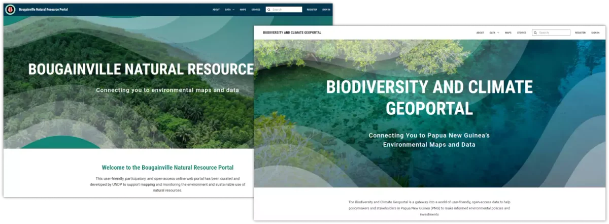
Figure: GeoNode-based portals developed by Mammoth Geospatial for managing, discovering and visualising environmental and biodiversity datasets.
My work included supporting the underlying GeoNode environment, spatial data migration, system upgrades, database backup and restoration, and troubleshooting containerised deployments.
The platforms combined GeoNode, PostGIS and QGIS with web mapping and data-visualisation technologies to make spatial information accessible to government, development and environmental stakeholders.
Kaleka Land-Use Planning
I contributed to the geospatial and backend components of Mammoth’s land-use capacity assessment application for Kaleka in Indonesia.
The application translated complex land-use scenarios into an interactive web workflow where users could assess potential environmental impacts and human carrying capacity.
The system used a Django and PostGIS backend together with GDAL-based spatial processing, with a Vue/Nuxt web interface providing access to the underlying modelling and analysis.
Spatial Databases & Backend Systems
PostgreSQL and PostGIS were central to many of the systems I worked on.
My work included designing and maintaining spatial database structures, integrating QGIS workflows with PostGIS, developing Python-based processing and data-access tools, and supporting PostgreSQL/PostGIS deployments in AWS environments.
I also worked with Docker-based application environments and backend services where spatial processing needed to move reliably between desktop GIS workflows, databases and web applications.
Representative Project Work
-
Agronomeye — AgTwin GIS workflows Developed QGIS and Python automation supporting the production of detailed farm datasets, including spatial validation, data extraction and raster/vector processing integrated with PostGIS.
-
UNDP — Papua New Guinea and Bougainville Geoportals Supported development and operation of GeoNode-based spatial data infrastructure, including data migration, application upgrades, Docker environments, PostGIS databases and deployment troubleshooting.
-
Kaleka — Land-Use Capacity Assessment Tool Contributed to a custom spatial web application using Django, PostGIS and GDAL to expose complex land-use analysis through an accessible web interface.
Engineering Approach
The common challenge across these projects was not simply performing spatial analysis, but turning GIS processes into repeatable, maintainable software systems.
That meant translating analyst workflows into Python and PyQGIS automation, designing reliable spatial data models, integrating desktop GIS with database and web environments, and maintaining systems that could continue to support real-world client workflows after delivery.